Cyclone Akvan Set for Powerful Andhra Landfall
🌀 Four days ago the global models could not agree where this system would end up. The spread ran from the north Andhra coast all the way round to Myanmar, and we drew that whole arc rather than pretend to a confidence nobody had — but VayuMet's own run had already picked a side, taking the system onto the Andhra coast at the south-western end of it. The models have now converged, and they have converged there. The system is Cyclone Akvan; IMD expects Very Severe Cyclonic Storm strength by the morning of 19 November and a crossing of the Andhra Pradesh coast between Nellore and Tuni around noon on 20 November, with winds of 120–130 km/h gusting to 145. An Orange cyclone alert is up for the Andhra and adjoining south Odisha coasts. ⚠️ One argument is left, and it is about how hard.
🧭 What Has Changed Since Friday
Three things. First, the system stopped wandering and organised: IMD's bulletin at 02:30 IST on 17 November put the centre at 12.2°N 85.7°E, about 610 km east of Chennai and 670 km south-southeast of Visakhapatnam, and noted it had been practically stationary for around nine hours. Second, the models converged — the Myanmar end of the fan is gone and the guidance now clusters on the Andhra coast, which is where our own run had been pointing since Friday. Third, it crossed the 62 km/h line and earned a name.
Akvan comes from Iran's entries on the WMO/ESCAP panel list. It traces to Akvan Div, a demon from Ferdowsi's Shahnameh. Press reports have glossed it as "evil mind"; the official list carries no translation, so treat the meaning as literary background rather than an official definition. It follows Arnab and Murasu — the third named cyclone from this basin in under four weeks, against a long-term average of three to four named storms in a whole season.
📍 Track and Intensity
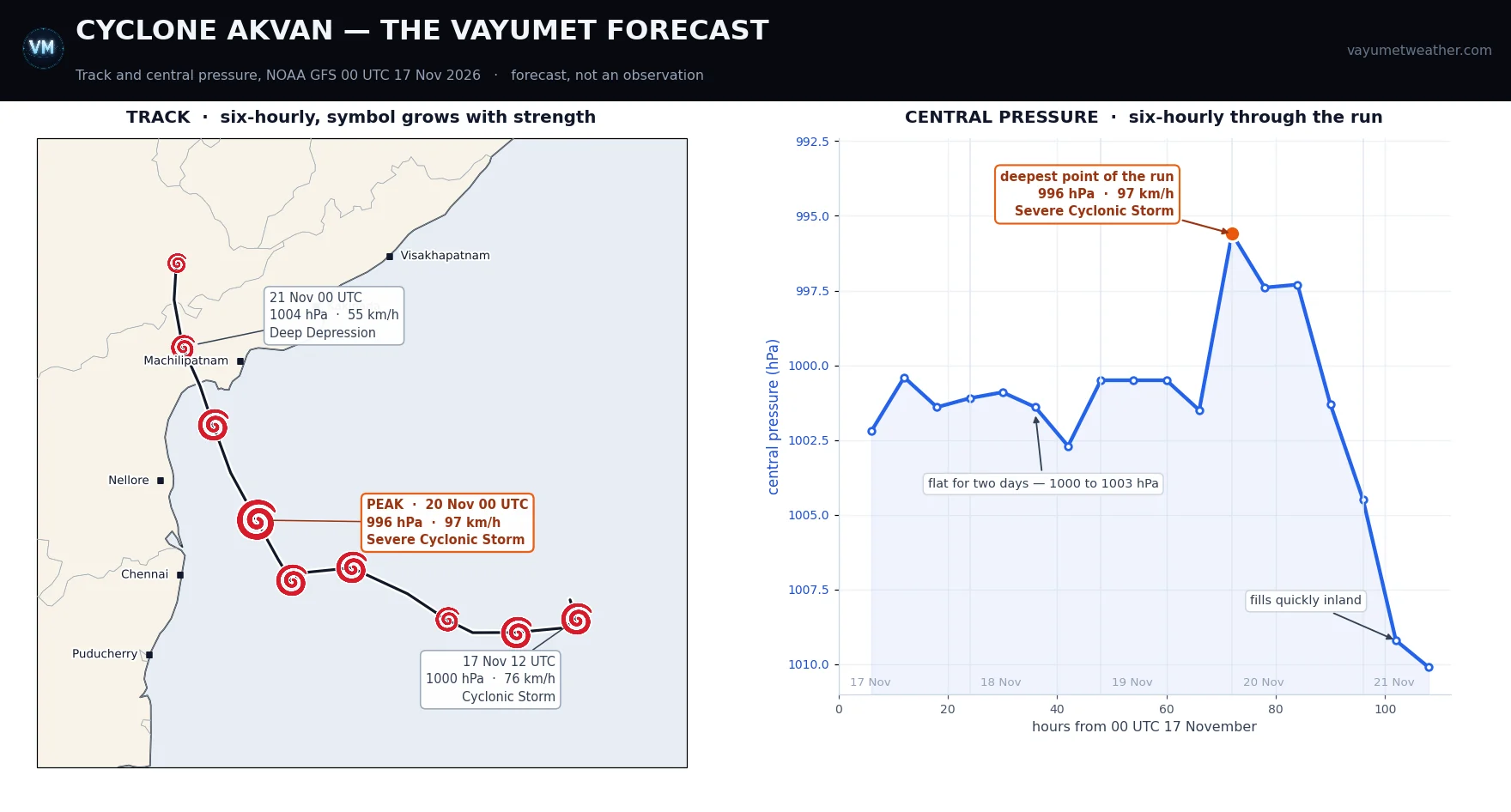
Both panels are the VayuMet forecast alone · left, the six-hourly track, symbol growing with intensity · right, central pressure through the run · NOAA GFS 00 UTC 17 Nov 2026 · forecast, not an observation. IMD's own figures are given in the text, not drawn on the chart.
The run takes Akvan west, then north-west: a slow westward crawl across the south-central Bay through the 18th, a turn towards the coast on the 19th, and a coast crossing on 20 November near the Ongole–Bapatla stretch, inside IMD's window. It weakens quickly over land and is a remnant low over Telangana by the 21st. On where and when, we and IMD now broadly agree.
⚡ How Strong: What the VayuMet Model Shows
The VayuMet model takes Akvan through a long, flat intensification rather than a sharp one. It holds the central pressure between 1000 and 1002 hPa for most of the system's life, with winds oscillating in the 67–88 km/h band — Cyclonic Storm strength, dropping briefly back to Deep Depression on the 18th as it reorganises.
The deepening comes late and it comes quickly. Through the night of 19–20 November the model drops the centre to about 996 hPa, its lowest of the run, with maximum sustained winds near 97 km/h and gusts to 104 km/h — Severe Cyclonic Storm strength, reached only hours before the coast. Then it weakens on arrival: back below Severe by the evening of the 20th, a Deep Depression by midnight, and a remnant low over Telangana through the 21st.
| Valid | Central pressure | Max wind | Stage in the VayuMet run |
|---|---|---|---|
| 17 Nov, 12 UTC | 1000 hPa | 76 km/h | Cyclonic Storm |
| 18 Nov, 18 UTC | 1003 hPa | 54 km/h | briefly Deep Depression |
| 19 Nov, 06 UTC | 1001 hPa | 80 km/h | Cyclonic Storm |
| 20 Nov, 00 UTC | 996 hPa | 97 km/h | Severe Cyclonic Storm — the run's peak |
| 20 Nov, 18 UTC | 1001 hPa | 72 km/h | weakening at the coast |
| 21 Nov, 06 UTC | 1009 hPa | 34 km/h | Depression, inland |
IMD is expecting more than this. Its bulletins have Akvan reaching Severe Cyclonic Storm strength by the evening of 17 November, Very Severe Cyclonic Storm by the morning of 19 November, and coming ashore at 120–130 km/h with gusts to 145. That is a full category above our run, and about 30 km/h more sustained wind at the coast.
What could settle it either way
Arguing for more intensification: Akvan has spent the last day over the open south-central Bay with a long run-up to the coast, and late November is when this basin produces its most intense storms. A system that organises slowly and then has 48 hours of warm water ahead of it is exactly the shape of a late-strengthening cyclone.
Arguing for a cap: two things. The first is the cold wake this site has been following all month — Arnab and Murasu have both ploughed across this Bay in the last three weeks, stirring cool water up from below along their tracks, and Akvan's final north-westward leg clips the band Arnab worked over. The second is subtler and comes from Akvan's own behaviour: a storm that sits still upwells cold water underneath itself. Nine hours of being practically stationary is nine hours of a cyclone chilling its own fuel supply. That is a real brake, and it is a plausible reason the VayuMet run keeps the ceiling where it does.
🔴 Prepare for the higher figure. With Arnab three weeks ago the VayuMet run was a category stronger than the official forecast and half a day quicker, and IMD's timing proved the better guide. A single model is one opinion, and the warning is the instruction. Plan for 120–130 km/h gusting 145. If it arrives at our number instead, you will have over-prepared for an afternoon, which costs nothing.
🌧️ The Severe Weather, Region by Region
IMD's rainfall warnings already run well beyond the landfall point: coastal Andhra Pradesh, Odisha and Rayalaseema, with north Tamil Nadu, Puducherry and Karaikal in line for heavy to very heavy rain on 18–19 November and a waterlogging risk, and Telangana districts for heavy to very heavy rain from 20 November as the remnant moves inland. Hyderabad is expected to stay largely dry.
For the coast itself, these are our run's district totals and peak gusts for 19–21 November — a floor, given the intensity gap above:
| District | Rainfall | Peak gust | State |
|---|---|---|---|
| Krishna | 128 mm | 86 km/h | Andhra Pradesh |
| Bhadradri Kothagudem | 109 mm | 53 km/h | Telangana |
| West Godavari | 90 mm | 57 km/h | Andhra Pradesh |
| Konaseema | 90 mm | 50 km/h | Andhra Pradesh |
| East Godavari | 86 mm | 57 km/h | Andhra Pradesh |
| Eluru | 81 mm | 66 km/h | Andhra Pradesh |
| Bapatla | 43 mm | 82 km/h | Andhra Pradesh |
| Guntur | 59 mm | 77 km/h | Andhra Pradesh |
Three hazards sit above the rainfall totals. Storm surge on the shallow shelf between Nellore and the Krishna mouth, worst to the right of wherever the centre crosses. Gale-force winds through the Krishna–Guntur–Bapatla belt, which on IMD's intensity means well above the 86 km/h our run shows. And cumulative soaking — this is the third system to wet the same ground in four weeks, so runoff will be faster and trees will come down at lower wind speeds than they otherwise would.
⚠️ Cautions — by Who You Are
🎣 Fishermen
The clearest instruction of the lot: do not go to sea off the Andhra, Odisha and north Tamil Nadu coasts, and return to harbour now if you are out. Odisha has already warned its fleet. Boats should be secured above the surge line, not merely moored.
🏘️ The public in the landfall belt
Be where you intend to spend the night of the 19th before dark. Charge everything; keep 72 hours of water, medicines and cash. Stay off the coast road and away from the shore during the crossing — and remember that a lull means the eye, not the end, with the wind returning from the opposite direction. Evacuate when told, not when convinced.
🌾 Agriculture
Standing paddy in the Krishna–Godavari delta is the single most exposed asset in the path, and it is at exactly the wrong stage. Harvest what can be harvested by the 19th, move cut produce off the field and onto raised, covered storage, and clear field drains today rather than after it starts. Secure polyhouses and shade nets; aquaculture ponds need their bunds and aerators checked now.
⚡ Power and telecom
The Arnab precedent is instructive: around 15,000 poles went down in Andhra Pradesh in late October. Pre-position crews, poles and transformers in Krishna, Guntur, Bapatla and Prakasam before the 19th — not after, when roads are blocked. Fuel the backup generators at hospitals, water-pumping stations and telecom towers.
🚢 Ports, shipping and aviation
Expect cyclone warning signals and suspended operations at the Andhra ports through 19–21 November, and cargo secured or moved. Airlines should plan for disruption at Vijayawada, Rajahmundry and Visakhapatnam around the crossing, and for low-visibility, heavy-rain operations at Chennai on the 18th–19th.
🏛️ District administrations
Odisha has 74 rescue teams deployed and early evacuation under way in its southern districts. The Andhra districts inside the Nellore–Tuni window should be at the same posture: shelters checked and provisioned, evacuation lists refreshed, heavy equipment staged for road clearance, and control rooms staffed through the night of the 19th.
✅ What to Watch Next
- This evening, 17 November: IMD expects Severe Cyclonic Storm status. If that happens on schedule, the Very Severe call for the 19th firms up and so does the case for the higher impact numbers.
- The 18–19 November runs: watch whether our model closes the intensity gap upwards or IMD eases downwards. Either way the track is now the settled part.
- The exact crossing point inside the window: Nellore to Tuni is still roughly 330 km of coast, and the surge and the worst winds land to the right of wherever the centre actually comes in.
🧭 The one idea to keep. When the models agree on the track and disagree on the strength, the track is the forecast and the strength is the risk. Prepare for the upper end of a disagreement, because the cost of being ready for a storm that under-performs is an afternoon — and the cost of the reverse is not.
Comments
⚠ Disclaimer
VayuMet's analysis is based on NOAA GFS model output and represents independent meteorological assessment. Before taking any decision based on weather forecasts, always consult your national official meteorological broadcaster for authoritative guidance. Where this article and IMD differ, follow IMD.
Data Source: Track, central pressure, winds and district figures: NOAA GFS 00 UTC 17 Nov 2026, derived from the run's own mean sea level pressure, 10 m wind and gust fields and placed on the standard IMD intensity scale. The central pressure is taken from a 3-cell smoothed field, because the raw grid minimum throws single-point spikes of several hPa that are an artefact of the grid rather than real deepening; maximum wind is taken within 1.5° of the centre · IMD position, milestones, landfall window, landfall intensity, the Orange cyclone alert and the regional rainfall warnings are as carried in press reporting of IMD's bulletins of 17 November 2026, including the national bulletin of 02:30 IST; VayuMet has not reproduced the bulletins directly · Name origin: Akvan is an Iranian entry on the WMO/ESCAP Panel on Tropical Cyclones list; the Shahnameh derivation and the "evil mind" gloss are press explanations, not official translations · The Arnab comparison (around 15,000 electricity poles lost in Andhra Pradesh) is from open-source reporting of late October 2026 and was preliminary at the time · District rainfall and gusts are VayuMet district warning system values and, given the intensity difference described above, should be read as a lower bound rather than a forecast of impact.