Three in Three Weeks: The Bay's Next Cyclone, and Why They Keep Coming
🌀 Arnab crossed the Andhra coast on 28 October. Murasu followed on 4 November. This morning there is a third low-pressure area over the southeast Bay of Bengal, under an upper-air cyclonic circulation near the Andaman Sea, and IMD expects it to become a depression by 15 November. The models agree it will reach cyclonic storm strength. They agree on almost nothing after that — the landfall possibilities run from the north Andhra coast all the way round to Myanmar. 🗺️ Which raises the question readers keep asking, and this piece actually goes and researches: why does this basin not stop, and is El Niño behind it?
🗺️ The Track, and an Honest Picture of the Spread
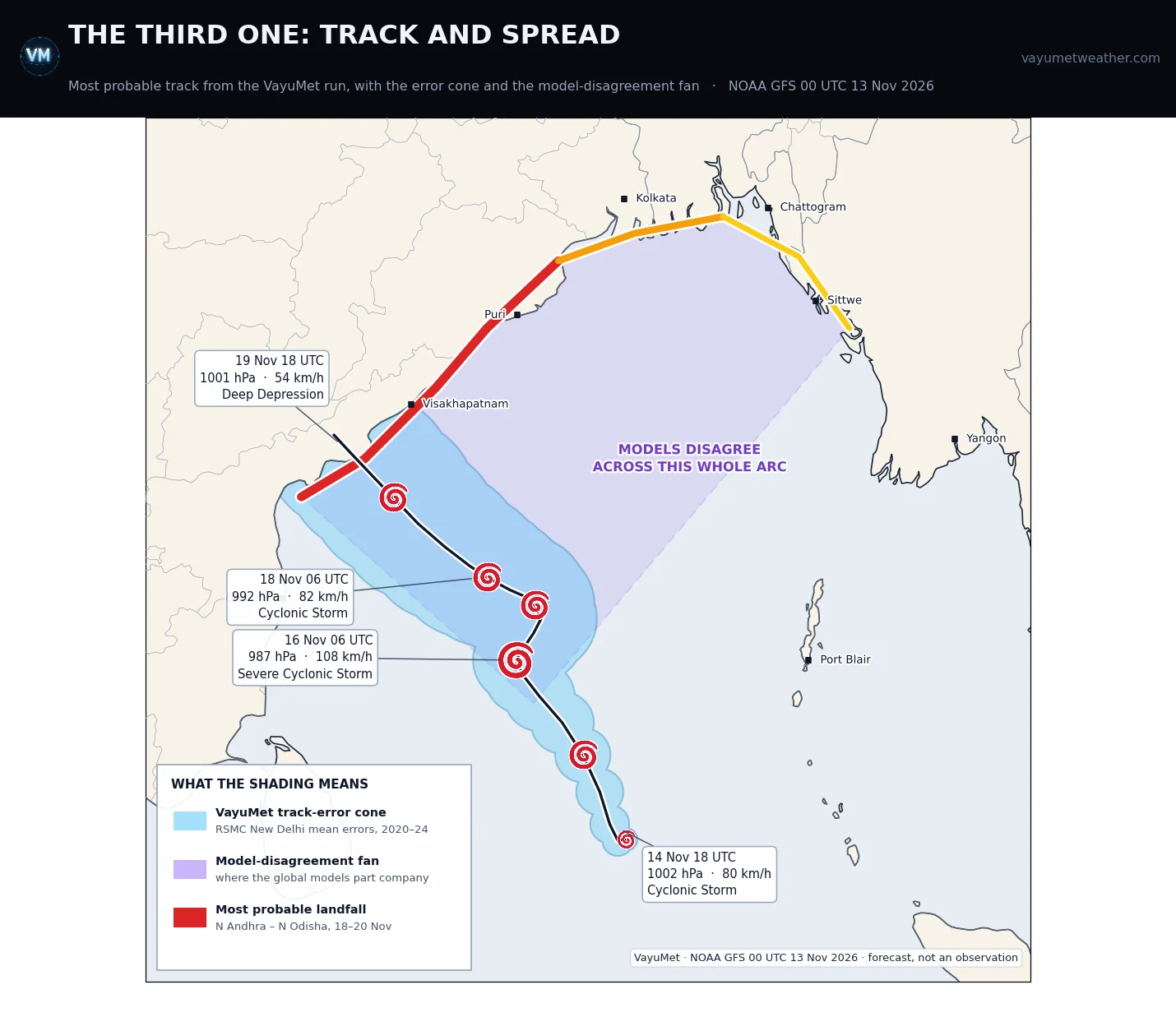
Most probable track, VayuMet · blue = track-error cone, scaled to RSMC New Delhi's 2020–24 mean official errors (72 / 111 / 154 / 183 km at 24 / 48 / 72 / 96 h) · violet = the model-disagreement fan, VayuMet's own depiction rather than any official product · the coastal arc is graded most probable → outside chance · NOAA GFS 00 UTC 13 Nov 2026 · forecast, not an observation
Two different uncertainties are drawn there, and it matters that they are kept apart. The blue cone is ordinary forecast error: how far an official track in this basin typically lands from the truth. The violet fan is the global models not agreeing on which track — a divergence far wider than any error cone.
The models are not agreeing on landfall. Between them they put it anywhere from the north Andhra coast round to the Myanmar coast — which is why the fan is drawn that wide, and why there is no sense in naming a town yet. Future runs will settle the track and the landfall point. Until they do, the width of that violet wedge is the honest answer.
VayuMet's own run sits at the southern end of that arc:
| Valid (UTC) | Position | Central pressure | Stage |
|---|---|---|---|
| 14 Nov 18 | 7.1°N 87.9°E | 1002 hPa | Cyclonic Storm strength |
| 16 Nov 06 | 11.6°N 85.1°E | 987 hPa | Severe Cyclonic Storm strength |
| 18 Nov 06 | 13.6°N 85.1°E | 992 hPa | Cyclonic Storm strength |
| 19 Nov 00 | 14.8°N 83.3°E | 983 hPa | run's deepest point |
| 19 Nov 18 | 16.6°N 81.6°E | 1001 hPa | weakening at the coast |
Note the stall between 16 and 18 November near 12–14°N. A system that sits still for two days is one whose steering has not been decided — which is precisely why the models fan out afterwards. Treat the dates as firmer than the place.
🌧️ What It Would Mean — Smaller Than Arnab, on Ground That Is Already Wet
IMD has squally winds of 40–50 km/h gusting to 60 over the Andaman Sea on 13–14 November, the southwest Bay 15–17 November and the central Bay 16–17 November. Fishermen have the clearest instruction in the forecast: stay out of those areas.
For the coast, this run is markedly gentler than the last two. Over 18–20 November it gives Guntur 110 mm, Krishna 78 mm and Srikakulam 67 mm, with peak gusts of 64–75 km/h around Kakinada, Anakapalli and West Godavari. A Heavy Rain event, not an Arnab — with the obvious caveat that this is a six-day forecast of a storm that is not yet a depression.
📊 Nine Systems — and Not One in the Arabian Sea
The clustering is real, but the season's arithmetic is stranger still. 2026 has so far produced nine depressions, six deep depressions, two cyclonic storms, two severe cyclonic storms and one very severe cyclonic storm, with 220 deaths and over $753 million in damage. Against a basin average of three to four cyclonic storms a season, the count is not extraordinary. This is:
Every single one of those nine systems formed in the Bay of Bengal. The Arabian Sea has produced nothing at all.
Then the recent run: Arnab 24–29 October, very severe, peaking at 155 km/h and 973 hPa; Murasu 31 October – 4 November, severe, 100 km/h; and now a third, nine days later.
⏱️ Has the Bay Done This Before? Yes — and Recently
It has. The closest documented parallel is late 2013, when the Bay produced Helen, Lehar and Madi in sequence across November and December — Lehar forming immediately after Helen dissipated, Madi eight days after Lehar's landfall. That sequence has its own study of why three storms came one after another.
So three in three weeks is unusual but not unprecedented. It belongs to a recognised habit of this basin: post-monsoon Bay cyclones arrive in bursts, not evenly — because what switches genesis on and off is not the season but something that cycles in weeks.
🌊 Is El Niño Doing This? The Research Answer
There is a very strong El Niño in progress, and the numbers are not marginal. The NOAA Climate Prediction Center's discussion of 12 November 2026 has an El Niño Advisory in effect, with Niño-3.4 at +2.5 °C, Niño-3 at +3.6 °C and Niño-1+2 at +4.4 °C, and a strong-to-very-strong event likely through January–March 2027 at better than a 79% chance. CPC puts the odds at roughly 60% that this becomes a historic event, exceeding every El Niño back to 1950.
So the obvious story writes itself: record El Niño, busy Bay. The published science says the opposite.
- Felton, Subrahmanyam and Murty (2013, Journal of Climate) examined 1979–2011 and found Niño-3.4 sea surface temperature anomalies are negatively correlated with Bay of Bengal tropical cyclone activity, significantly, at a five-month lead. It is La Niña that helps: more variance in the 10 m zonal winds, low vertical wind shear over the central and northern Bay, and more moisture.
- Roose, Ajayamohan, Ray, Mohan and Mohanakumar (2022, npj Climate and Atmospheric Science) found that post-monsoon years with fewer low-latitude Bay cyclones are the ones with anomalous equatorial easterlies, "largely connected with the El Niño and positive IOD", while La Niña's equatorial westerlies supply the spin-up that gets cyclogenesis started.
Both point the same way: a strong El Niño should be making the Bay quieter. This season it is not. Two things resolve most of that, and neither is hand-waving.
First, where ENSO actually has its grip. The 2022 paper's central finding is that the teleconnection is confined to low latitudes — cyclones forming between 5°N and 10°N, about 40% of the Bay's total. North of 10°N it reports "little influence for cyclogenesis" at all. Arnab formed over the central Bay, Murasu over the Andaman Sea; most of this season's systems started north of the band El Niño governs. Which makes the system forming now genuinely interesting: it is spinning up near 7°N — inside the band El Niño is supposed to be shutting down.
Second — and this is the one actually helping these storms form — the Madden–Julian Oscillation. The MJO is an eastward-moving pulse of enhanced convection that circles the tropics every 30–60 days. When it parks over the Indian Ocean it does three things a developing cyclone needs all at once: it lifts air, cuts the vertical wind shear and pumps in moisture. That is why tropical cyclones arrive in clusters rather than evenly.
The Australian Bureau of Meteorology reported on 10 November that a moderate-to-strong MJO pulse is sitting over the Indian Ocean and has been relatively stationary for the past week. A stalled pulse over this ocean is a fortnight-long open window for cyclogenesis — and it was already credited with enhancing the thunderstorm activity that built Arnab. Three storms in three weeks is what that window looks like from the coast. ENSO sets the season's odds; the MJO decides which three weeks.
🔗 One literal Pacific connection, though. The deep depression of 28–30 September did not form in the Bay at all. It came from an upper-air circulation over southern Thailand and Myanmar, traced to the remnants of a Pacific tropical depression on 25 September. Western Pacific systems do occasionally cross Indochina and regenerate over the Bay — a direct hand-off, not a teleconnection, and this year the Bay received one.
✅ What to Watch
- 15–16 November: once IMD classifies a depression it is being tracked rather than predicted, and the arc should narrow sharply.
- The stall: if it sits near 12–14°N as this run suggests, expect the models to keep disagreeing until it moves again.
- Coastal Andhra and south Odisha: nothing expensive yet, but the ground is still wet from two storms — what matters is not the largest total, it is the one falling on saturated soil.
- Fishermen: the Andaman Sea today and tomorrow, the southwest and central Bay from the 15th.
🧭 The one idea to keep. When a basin goes quiet or busy for a season, look at ENSO. When it fires three storms in three weeks, look at the MJO. They are different clocks, and this November the fast one is winning.
Comments
⚠ Disclaimer
VayuMet's analysis is based on NOAA GFS model output and represents independent meteorological assessment. Before taking any decision based on weather forecasts, always consult your national official meteorological broadcaster for authoritative guidance.
Data Source: Track, central pressure and stage: NOAA GFS 00 UTC 13 Nov 2026, derived from the run's own mean sea level pressure and 10 m wind fields and placed on the standard IMD intensity scale; the maximum wind is taken within 1.5° of the centre so that unrelated wind maxima are excluded while the system is weak · Track-error cone: circles scaled to RSMC New Delhi's annual verification report figures — 2020–24 mean official track errors of 72, 111, 154 and 183 km at 24, 48, 72 and 96 hours, extrapolated to about 210 km at 120 hours · Model-disagreement fan and landfall arc: VayuMet's own depiction of the range of landfall locations the models currently span. It is not an ensemble product and carries no calibrated probabilities · ENSO figures: NOAA Climate Prediction Center ENSO Diagnostic Discussion, 12 November 2026 · MJO: Australian Bureau of Meteorology MJO monitoring, 10 November 2026 · Season statistics and storm histories: the 2026 North Indian Ocean cyclone season and Cyclone Arnab articles on Wikipedia, which are live and may be revised · Research cited: Felton, Subrahmanyam & Murty, "ENSO-Modulated Cyclogenesis over the Bay of Bengal", Journal of Climate 26(24), 2013; Roose, Ajayamohan, Ray, Mohan & Mohanakumar, "ENSO influence on Bay of Bengal cyclogenesis confined to low latitudes", npj Climate and Atmospheric Science, 2022 — both quoted from their published abstracts · This system is not yet a depression. Nothing here is a warning; IMD has issued no cyclone classification, landfall point or date.