The Valsad Trough Is Back — Monsoon Depression Tracks Westward Toward Gujarat; Same Offshore Zone That Delivered India's Third-Highest Daily Rainfall Now Under Watch
Six days after the Valsad coast registered India's third-highest daily rainfall in recorded history, the same offshore trough is waking up again. A well-marked depression centred over South Chhattisgarh (~994 hPa) at 29 July 1800 UTC is tracking westward, and the 24-hour MSLP tendency (P24P24) already shows pressure falling by −4 to −6 hPa over Gujarat and Maharashtra — a clear leading signal that very active monsoon conditions will arrive there within the next 24–36 hours. A broad east–west rainfall band is organising along the Chhattisgarh–Madhya Pradesh–Maharashtra–South Gujarat axis, with the South Gujarat and Valsad coast in the direct firing line by 31 July.
29 Jul 1800 UTC
Ahead of System
Westward Landfall
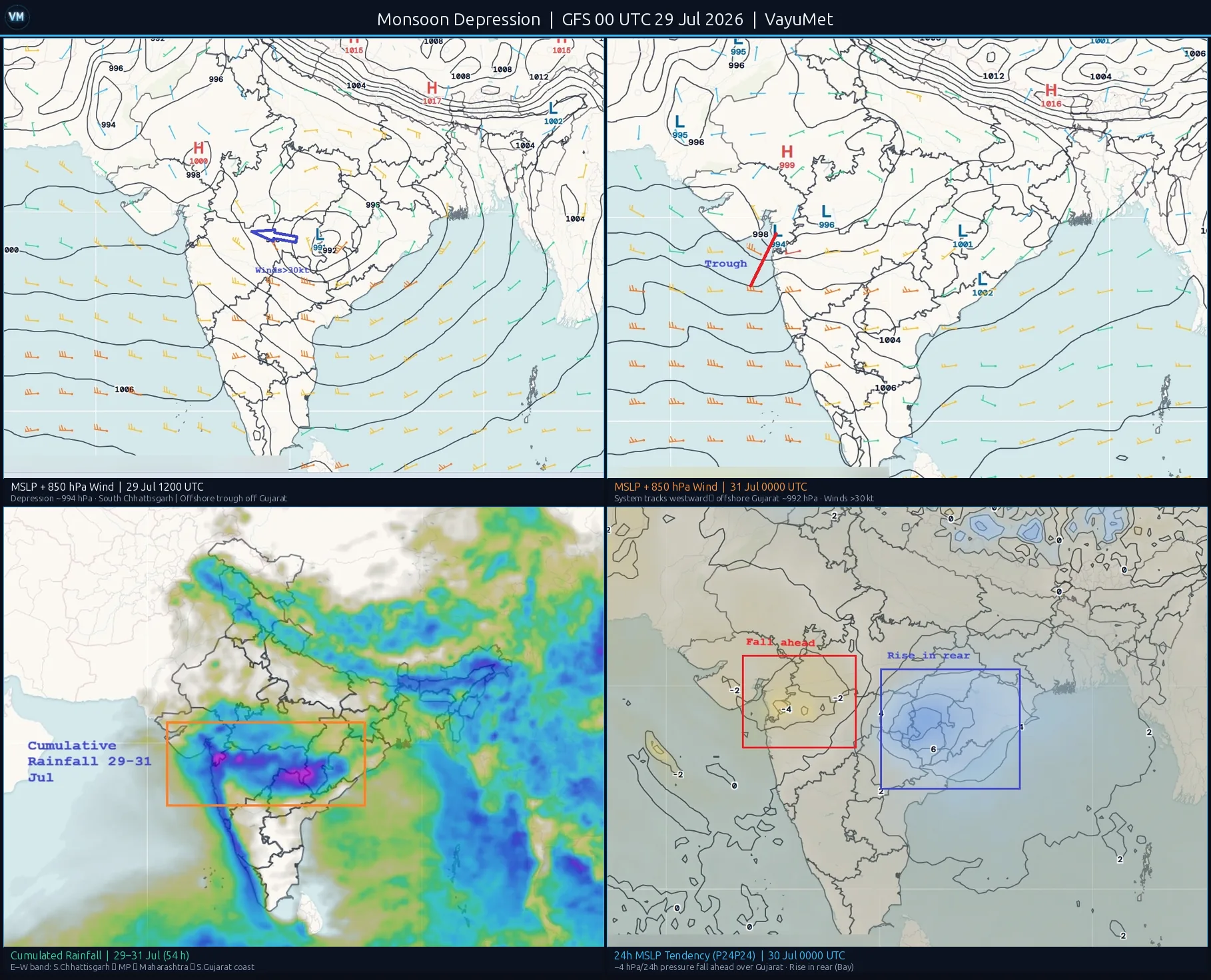
Top-left: MSLP + 850 hPa wind — 29 Jul 1200 UTC. Depression centred over South Chhattisgarh (~994 hPa); cyclonic circulation at 850 hPa; offshore trough axis off Gujarat coast; monsoon trough along Rajasthan–Gangetic plains. Top-right: MSLP + 850 hPa wind — 31 Jul 0000 UTC. Depression has tracked westward to offshore Gujarat (~992 hPa); winds exceeding 30 kt near centre; offshore trough energised; convergence zone intensifying over South Gujarat coast. Bottom-left: Cumulated rainfall 29–31 Jul (54h). East–west band from South Chhattisgarh/Vidarbha (Extremely Heavy, magenta) through MP/Maharashtra (Very Heavy) to South Gujarat and Valsad coast (Very Heavy). Data: GFS IC 00 UTC 29 Jul 2026. Bottom-right: 24h MSLP tendency (P24P24) valid 30 Jul 0000 UTC. Blue = pressure falling. Strong −4 hPa/24h signal over Gujarat indicates the system's advance guard — active weather arrives before the surface centre crosses. Rise in rear (Bay of Bengal) confirms classic wave pattern.
Synoptic Setup — A Well-Marked System Over South Chhattisgarh
At 29 July 1800 UTC, the VayuMet model shows a well-marked depression with central pressure near 994 hPa over South Chhattisgarh, close to the Chhattisgarh–Odisha–Telangana tri-junction area. A closed cyclonic circulation is clearly identifiable at the 850 hPa level, with wind barbs rotating cyclonically around the centre. The monsoon trough runs from the depression centre northwestward across Madhya Pradesh and into Rajasthan, anchoring the rainfall axis firmly in central India.
The offshore trough off the Gujarat coast — a semi-permanent feature of active monsoon weeks along the Konkan and Saurashtra coast — is already established and energised. This is significant: the combination of a depression tracking westward and an active offshore trough creates the same meridional stacking of circulation systems that was responsible for the extraordinary Valsad event on 22–23 July.
Reading the P24P24 — Pressure Falling −4 to −6 hPa Ahead of the System
The 24-hour MSLP tendency chart (P24P24 valid 30 July 0600 UTC) shows what is about to arrive before the surface low itself does. P24P24 represents the change in mean sea-level pressure over the preceding 24 hours: blue areas (negative values) indicate pressure has fallen, signalling an approaching active weather system; red areas indicate pressure has risen, signalling clearing conditions behind the system.
The chart shows a coherent −4 to −6 hPa negative tendency covering Gujarat, northern Maharashtra, and southern Rajasthan. This is not a local signal — it is a region-wide fall indicating that the depression's influence is already felt hundreds of kilometres ahead of its centre. Simultaneously, the offshore trough zone off the Gujarat coast shows its own falling-pressure signal, confirming that the coastal mechanism is re-activating independently of the interior low.
What the P24P24 signal means in practice: When pressure falls −4 to −6 hPa in 24 hours over a coastal region, it signals strong low-level convergence and active convective organisation arriving within the next 12–36 hours. This is not a routine monsoon signal — it is the signature of a rapidly approaching and intensifying system.
East–West Rainfall Band — Chhattisgarh to South Gujarat
The cumulated rainfall chart (29–31 July, 54 hours) reveals an elongated east–west band of Very Heavy to Extremely Heavy Rain stretching from South Chhattisgarh and Vidarbha westward through Madhya Pradesh and Maharashtra to the South Gujarat coast. This is the classic rainfall signature of a monsoon depression tracking across central India: the heaviest rainfall occurs to the south and southeast of the depression track, while the westward advance of the system extends the rain band to the coast.
South Chhattisgarh and Vidarbha are closest to the depression centre and receive the earliest, most intense rainfall — Extremely Heavy Rain (≥ 204.5 mm/24h) signals are possible here on 29–30 July. Madhya Pradesh and northern Maharashtra pick up Very Heavy Rain as the trough axis passes through. South Gujarat and the Valsad–Navsari–Surat coastal belt emerge as the critical zone by 30–31 July, when the combination of the approaching surface low and the re-energised offshore trough creates conditions strikingly similar to 22–23 July.
The Valsad Comparison — Same Geography, One Critical Ingredient Missing
On 22–23 July, the Valsad–Umbergaon coast recorded 1,064 mm in 24 hours — India's third-highest daily rainfall on record. The mechanism required five ingredients acting simultaneously. Full case analysis →
| INGREDIENT | 22–23 JUL (VALSAD EVENT) | 29–31 JUL (CURRENT) |
|---|---|---|
| Surface low / depression approaching coast | ✓ Present | ✓ Present |
| Offshore trough anchored off South Gujarat coast | ✓ Present | ✓ Present |
| 850 hPa Arabian Sea Low-Level Jet (LLJ) surging | ✓ Present | ✓ Present |
| Mid-Tropospheric Circulation (MTC) stacked over Valsad coast | ✓ Present | ✗ Not evident |
| Steering flow stalling system over the coast | ✓ Present | ? Unresolved at 54h |
The critical difference is the Mid-Tropospheric Circulation (MTC). On 22–23 July, a mid-level vortex (around 500–700 hPa) was vertically stacked directly over the Valsad coast, locking the deep convective column in place and preventing the rainfall from moving with the surface system. That vertical coherence — low-level convergence from the offshore trough, mid-level spin from the MTC, upper-level outflow from the Tibetan High — created a nearly stationary convective chimney over the same 50 km stretch of coastline for 18+ hours straight.
In the current setup, no equivalent mid-tropospheric circulation is evident over the Gujarat coast in the VayuMet model output. The surface depression is deeper and better-organised than the July 22 low was, but without the MTC stacking vertically, the system is more likely to produce a broad swath of Very Heavy Rain across South Gujarat rather than an extreme concentrated event at a single location. That distinction matters enormously for impact forecasting.
Watch — South Gujarat and Valsad Coast 30–31 July: Three of the five mechanism ingredients are present. Very Heavy to Extremely Heavy Rain is likely across the South Gujarat belt. A repeat of the 22–23 July extreme concentration is less likely without an MTC — but the offshore trough and approaching depression alone are sufficient to produce severe flooding conditions. Monitor the 30 July 00 UTC and 12 UTC model runs and IMD district bulletins for official warnings.
VayuMet Outlook — 29 July to 02 August 2026
29–31 July — Depression Active, Rainfall Band Organised
The depression remains the dominant synoptic driver. South Chhattisgarh, Vidarbha, and the eastern fringe of Madhya Pradesh are under the most intense rainfall on 29–30 July, with Extremely Heavy Rain possible in districts closest to the depression centre. As the system tracks west, the rainfall axis shifts: northern Maharashtra (Nashik, Dhule, Nandurbar, Jalgaon belt) and South Gujarat (Surat, Navsari, Valsad, Tapi, Dang) enter the active zone from 30 July and into 31 July. The offshore trough keeps Konkan wet throughout. No break in the monsoon trough is signalled.
01–02 August — Post-Depression Transition
By 31 July the depression will have made landfall or weakened over the Gujarat/Saurashtra coast. The residual circulation is likely to persist for 12–24 hours before dissipating. The post-system period (01–02 August) typically sees a brief easing of organised rainfall before the monsoon trough re-establishes. Northeast India and sub-Himalayan West Bengal remain active throughout, fed by independent Bay of Bengal moisture. The upper-level structure (Tibetan High well-placed, Tropical Easterly Jet (TEJ) active) provides no indication of a break monsoon signal through 02 August.
Comments
⚠ Disclaimer
VayuMet's analysis is based on NOAA GFS model output and represents independent meteorological assessment. Before taking any decision based on weather forecasts, always consult your national official meteorological broadcaster for authoritative guidance.
Data Source: GFS IC 00 UTC 29 Jul 2026 · P24P24 = 24h MSLP tendency (derived) · Cumulated rainfall = GFS APCP 54h · District alerts: VayuMet district forecast system