1,064 mm in a Day — Anatomy of the Valsad Deluge, India's Third-Highest Daily Rainfall Ever
In 24 hours to the morning of 23 July 2026, Umbergaon in Valsad district, south Gujarat, logged 1,064 mm of rain — the third-highest daily total ever recorded in India — and over 1,200 mm in 36 hours. Ten districts went under a Red warning. VayuMet's 22 July run had already flagged the south Gujarat heavy-rain threat. So what turned an active monsoon spell into a top-three record? The charts give a clean answer: by 23 July a well-marked low, a surging Arabian Sea Low-Level Jet, an offshore trough, a mid-level cyclonic circulation and upper-level divergence had stacked into the same vertical column over Valsad — and, with almost no steering flow, stayed there for a day and a half.
Umbergaon, Valsad
IMD Warning
VayuMet Call
The Event — What IMD Reported
IMD event summary — 22–23 July 2026: Extremely Heavy Rain at isolated places over south Gujarat (Valsad, Navsari, Tapi, Surat, Dang) and Daman and Dadra & Nagar Haveli. Umbergaon (Valsad) recorded ~1,064 mm in 24 hours to the morning of 23 July — over 1,200 mm in 36 hours — the third-highest daily rainfall on India's record. Impacts: 22,000+ evacuated, ~1,200 rescued, 1,200+ roads closed, 35+ power substations down, and a Red warning over 10 districts. Source: IMD bulletins and press reporting, 23 July 2026; figures provisional.
VayuMet Analysis — How the Charts Read It
We ran the GFS 00 and 12 UTC analyses across 22–23 July and marked each feature directly on the charts (star = Valsad). It confirms the large-scale set-up IMD described — monsoon trough over northwest India, an east–west shear zone near 23°N — but resolves why the rain unloaded on this coast. Notably, the shear zone tilts southward with height: the 500 hPa zonal-wind reversal sits near 21–22°N, essentially over south Gujarat, rather than at the ~23°N lower-tropospheric axis.
22 July — The Ingredients Move Into Place
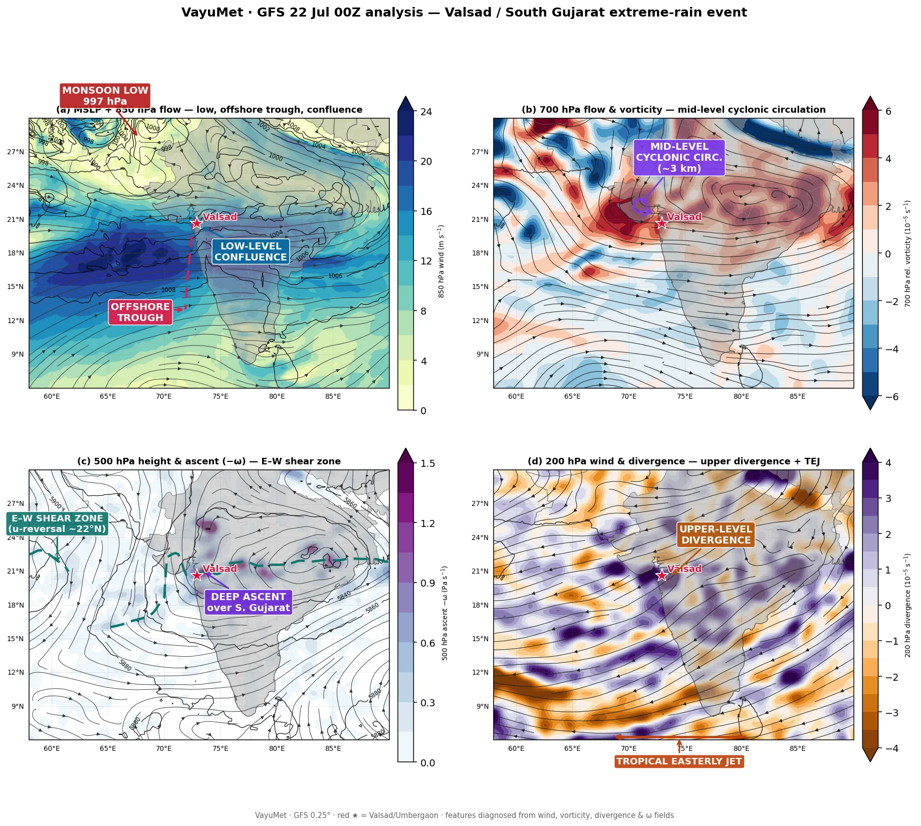
VayuMet · GFS 0.25° 00 UTC 22 Jul 2026 · (a) MSLP + 850 hPa flow · (b) 700 hPa flow & vorticity · (c) 500 hPa height & ascent (−ω) · (d) 200 hPa wind & divergence · red ★ = Valsad
The monsoon low over northwest India drives a powerful Arabian Sea Low-Level Jet (LLJ) — moisture-laden southwesterlies at ~1.5 km — that exceeds 24 m/s offshore and turns onshore into south Gujarat at ~16 m/s, piling into the offshore trough and forming a low-level confluence right at Valsad (panel a). A mid-level cyclonic circulation sits over Saurashtra at 700 hPa (b), 500 hPa ascent builds along the east–west shear zone, whose axis dips right over south Gujarat at this level (c), and 200 hPa divergence on the flank of the Tropical Easterly Jet (TEJ) vents the column aloft (d). The 700 hPa air over Valsad is already saturated; Convective Available Potential Energy (CAPE) runs ~1,400 J/kg.
23 July — Everything Stacks Over Valsad
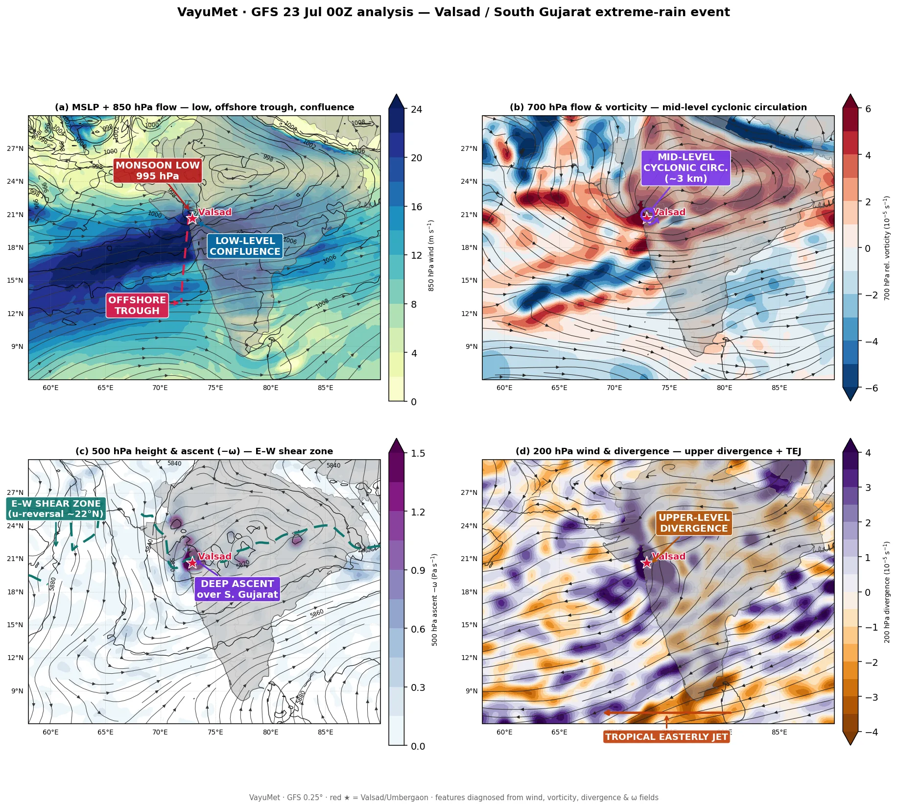
VayuMet · GFS 0.25° 00 UTC 23 Jul 2026 · (a) MSLP + 850 hPa flow · (b) 700 hPa flow & vorticity · (c) 500 hPa height & ascent (−ω) · (d) 200 hPa wind & divergence · red ★ = Valsad
This is the event's signature. The features spread across the region on 22 July have now aligned in one vertical column over south Gujarat: a well-marked surface low (~995 hPa) on the Valsad coast with the coastal LLJ surging to ~25 m/s (~89 km/h) (a); the 700 hPa cyclonic circulation (vorticity ~20 × 10⁻⁵ s⁻¹) centred right over Valsad (b); a sharp maximum of 500 hPa deep ascent over the same point (c); and 200 hPa divergence (~16 × 10⁻⁵ s⁻¹) directly overhead (d). Low-level convergence, mid-level lift and upper-level venting locked over one coast — with the northern Western Ghats adding orographic push and near-zero steering to move any of it. The column barely budged for 36 hours. By 23 July 12 UTC the low deepened to ~991 hPa and lifted north, spreading Extremely Heavy Rain to the Ahmedabad region (Dholka 339 mm in 12 hours).
Why Valsad — The Ingredients That Stacked Up
No single feature here was extraordinary for the monsoon. The record came from five ordinary ingredients aligning in one vertical column — and staying there:
- Well-marked low tracking onto the south Gujarat coast (~995 → 991 hPa) — anchored deep convergence directly over Valsad rather than out at sea or far inland.
- Surging Arabian Sea Low-Level Jet (coastal ~16 → 25 m/s) — drove a relentless, near-saturated southwesterly moisture feed (700 hPa relative humidity ~100%) straight into the coast.
- Offshore trough + Western Ghats orography — forced the moist jet to rise exactly where the Ghats meet the coast at Umbergaon, the wettest focal point.
- Mid-level cyclonic circulation stacked over the low — 700 hPa vorticity (~20 × 10⁻⁵ s⁻¹) sitting over Valsad deepened the ascent through the mid-troposphere, and near-zero steering held it in place for 36 hours.
- Upper-level divergence under the Tropical Easterly Jet — 200 hPa divergence directly overhead (~16 × 10⁻⁵ s⁻¹) vented the column and sustained deep convection instead of capping it. CAPE ran ~1,000–1,400 J/kg throughout.
Observed Station Rainfall — IMD Reports (22–23 July 2026)
Provisional station totals as reported by IMD and press sources. Intensity labels use IMD 24-hour categories; the multi-day belt totals below far exceed the Extremely Heavy Rain threshold (≥ 204.5 mm/24 h).
| Station / Taluka | District | Reported Total | Category |
|---|---|---|---|
| Umbergaon (Umargam) | Valsad | ~1,064 mm / 24 h · >1,200 mm / 36 h | EXTREMELY HEAVY |
| Khergam | Navsari | ~800 mm / 36 h | EXTREMELY HEAVY |
| Chikhli | Navsari | ~650 mm / 36 h | EXTREMELY HEAVY |
| Dholka | Ahmedabad | 339 mm / 12 h (23 Jul PM) | EXTREMELY HEAVY |
Figures provisional; verify against official IMD bulletins. IMD 24-hour categories: Very Heavy Rain 115.6–204.4 mm · Extremely Heavy Rain ≥ 204.5 mm.
VayuMet Takeaway
On India's west coast, the difference between a heavy spell and a record is vertical alignment and persistence, not just intensity. When a well-marked low, a mid-level circulation and upper divergence stack over the coast with a surging Arabian Sea Low-Level Jet and weak steering, the Valsad–Navsari–Daman belt is the address to watch — that is where the marine jet, the offshore trough and the northern Western Ghats intersect. While this configuration holds, Very Heavy to isolated Extremely Heavy Rain remains likely over south Gujarat and the adjoining Konkan; the threat eases only once the jet relaxes or the trough shifts north.
Comments
⚠ Disclaimer
VayuMet's analysis is based on NOAA GFS model output and represents independent meteorological assessment. Before taking any decision based on weather forecasts, always consult your national official meteorological broadcaster for authoritative guidance.
Data Source: GFS IC 00 & 12 UTC 22–23 Jul 2026 · Derived fields: relative vorticity, divergence, vertical velocity (ω) · Observed rainfall: IMD provisional station reports · Synoptic context: IMD bulletins 23 Jul 2026