One Low Will Die Off Somalia. The Other Is Walking Toward Odisha.
There are two low pressure areas on the map this morning, one ocean apart, and only one of them matters to India. The Arabian Sea system near 8.5°N, 58°E drifts west-northwest all week, loses its heat source and fills near the Horn of Africa — a non-event for the Indian coast. The other has not formed yet. The VayuMet model spins it up over the Andaman Sea around 21–23 October, deepens it to Very Severe Cyclonic Storm intensity as it turns northwest, and drives it onto the north Odisha coast around 27 October. That is nine days out — and the official picture is split. IMD's cyclone information page shows nil cyclogenesis over the Bay of Bengal for the next 168 hours, yet IMD's own Bharat Forecast System does show a system forming over the Andaman Sea on 25 October. The guidance disagrees with itself, and mostly about timing. This article is about what to do while that resolves.
First, the One You Can Ignore
The Arabian Sea low sits near 8.5°N, 58°E this morning at about 1,012 hPa, with model winds of 40–55 km/h at best. It tracks west-northwest then due west all week — near 9°N, 55°E by 22 October, 8.5°N, 49°E by the 23rd, into the approaches to the Horn of Africa by the 24th–25th, where it fills over cooler water and dry continental air off Somalia and Yemen. It never turns toward India and never organises. Noted, and set aside.
Now the One That Matters: Andaman Sea to the Odisha Coast
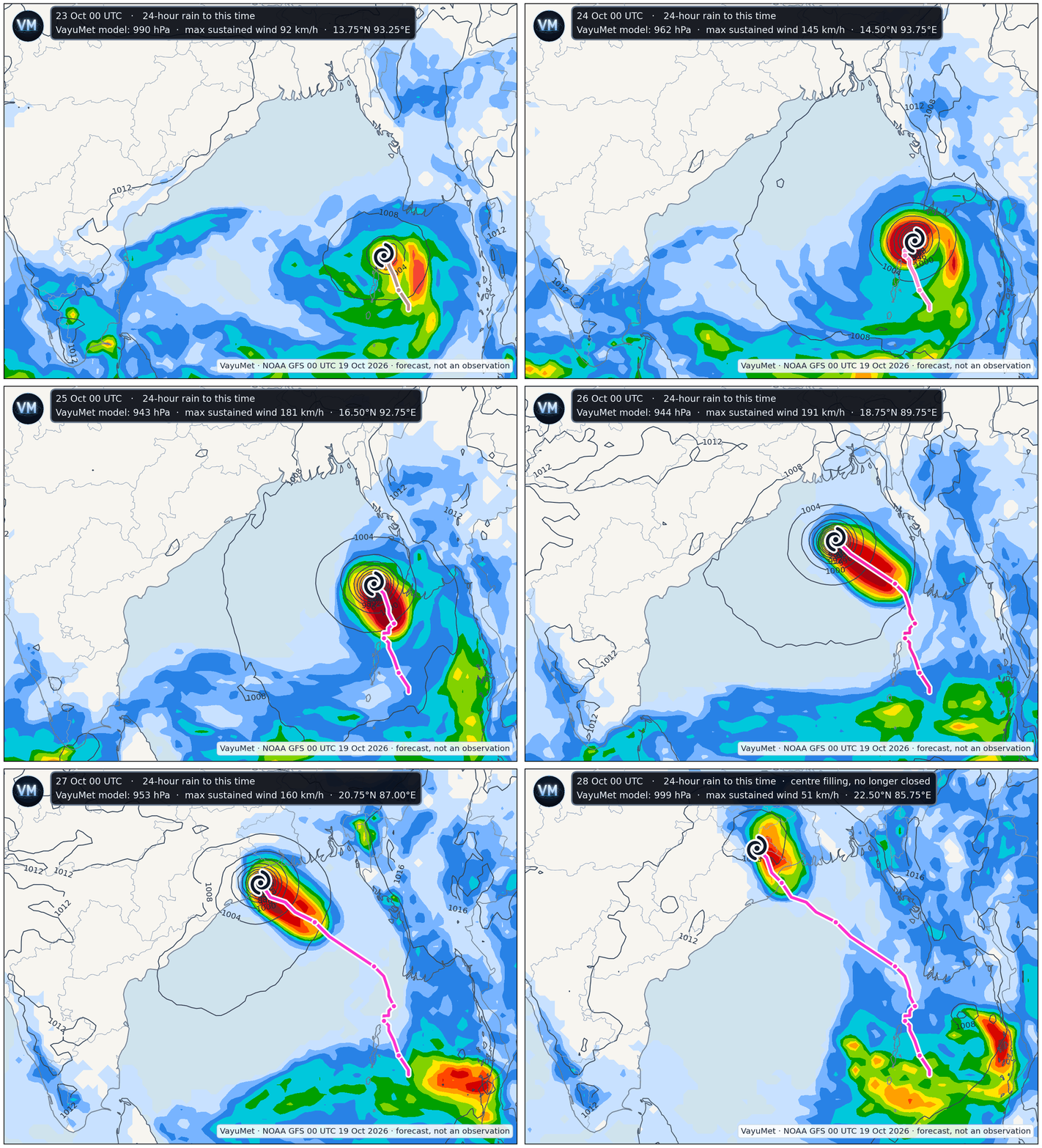
VayuMet model, NOAA GFS 00 UTC 19 Oct 2026 · 24-hour rain and mean sea level pressure, 23–28 October · the spiral is the standard cyclone symbol marking the model's centre — it carries no intensity grading · magenta trail is the 6-hourly track so far · forecast, not an observation
Three things to watch as it loops. The centre tracks north out of the Andaman Sea, then turns northwest. The pressure collapses between 22 and 25 October — the model's boldest claim. And the rain shield reaches the coast a day before the centre does, which is why the first dangerous day is the 26th, not the 27th.
The Track, and What the Numbers Would Mean
| Valid (UTC) | Model position | Central pressure | Max sustained wind |
|---|---|---|---|
| 21 Oct 12Z | Andaman Sea, 11.0°N 94.5°E | 1008 hPa | 44 km/h |
| 23 Oct 00Z | 13.8°N 93.3°E | 990 hPa | 92 km/h |
| 25 Oct 06Z | Central Bay, 17.0°N 92.0°E | 939 hPa | 194 km/h |
| 26 Oct 18Z | ~90 km off Kendrapara | 952 hPa | 167 km/h |
| 27 Oct 00Z | Coast crossing, Kendrapara–Bhadrak | 953 hPa | 160 km/h |
| 27 Oct 18Z | Inland, Mayurbhanj | 999 hPa | 51 km/h |
Single deterministic run. No classification is implied or applied — IMD has declared no system.
So how strong does the model make it? Strong enough that the question matters. Put this run's sustained winds against IMD's wind scale and they would correspond to Very Severe Cyclonic Storm intensity from about 24 October — crossing into Extremely Severe at the 25 October peak of 194 km/h — and still Very Severe, near 160 km/h, as the centre reaches the coast. That is the model forecasting rapid intensification over a warm, low-shear Bay, which is exactly the setup October provides.
Those are the words that fit the numbers — they are not a classification. A classification is IMD's to issue, and IMD has issued none. Intensity is also the least reliable quantity a model produces at seven to nine days, and a single run bottoming near 939 hPa is that solution's upper bound, not a forecast.
And here is what should temper all of it. IMD's cyclone information page shows nil cyclogenesis over the Bay of Bengal for the next 168 hours — not a weak system, not a depression, nothing. But the official picture is not unanimous: IMD's own Bharat Forecast System does develop a system over the Andaman Sea on 25 October, two to four days later than this GFS run. So the live question is not really whether something forms, it is when — and a later genesis means a later, and probably weaker, arrival at the coast. No system exists today, IMD has declared nothing, and no one else's label counts until it does. That is why nothing on the map above is graded to the cyclone scale: the spiral simply marks where this run puts a centre.
Why the Track Is the Believable Part
If it happens at all, it is exactly where October systems go. IMD's own climatology is blunt about the seasonal march: Bay of Bengal cyclones strike the Odisha–West Bengal coast most often in October, the Andhra coast most often in November, and the Tamil Nadu coast in December. The model has not produced an exotic solution; it has produced the climatological favourite for this specific week.
The base rates fill in the rest. Over 1891–2022 roughly 60% of Bay storms make landfall on India's east coast, about 30% on Bangladesh or Myanmar, and some 13% dissipate at sea without landfall at all. The North Indian Ocean averages around five cyclonic storms a year and the Bay outproduces the Arabian Sea by roughly four to one, with the season peaking now. Longer-run work on 1877–2016 tracks finds the median strike point has shifted eastward over the record, with northern Odisha and the Sundarbans standing out as the highest-impact zone.
A system forming in the Andaman Sea in the fourth week of October and heading for north Odisha is therefore no surprise. What stays open is whether it forms at all, whether it reaches the intensity this run advertises, and whether the crossing slides east into West Bengal or west toward Puri — a 100 km shift changes who takes the dangerous right-hand semicircle.
The Severe Weather, If This Run Verifies
| Date | Where | Rain | Model gusts |
|---|---|---|---|
| 26 Oct | Kendrapara, Bhadrak, Jajapur, Jagatsinghpur, Baleshwar (Odisha) | Very Heavy | 150–160 km/h |
| 27 Oct | Mayurbhanj, Baleshwar, Kendujhar (Odisha) · Purbi Singhbhum (Jharkhand) · Puruliya, Jhargram, Paschim Medinipur (West Bengal) | Very Heavy | 100–130 km/h |
| 28 Oct | Remnant trough into Jharkhand and Bihar | Heavy, isolated | under 60 km/h |
Model guidance only — verify against latest IMD district bulletins.
Three hazards travel together here, and they do not peak at the same hour. Wind peaks at the coast on the 26th and 27th; at 150 km/h gusts you lose power poles, kutcha roofing and standing trees. Rain peaks inland on the 27th, over Mayurbhanj, Singhbhum and the Puruliya–Jhargram belt — hilly, fast-draining country where Very Heavy Rain becomes flash flooding within hours. And with the model holding the centre under 990 hPa right at the coastline, storm surge on the shallow north Odisha shelf is a live concern for the low-lying tracts of Kendrapara, Bhadrak and Jagatsinghpur.
What to Do With This, Today
Nothing here is a warning. IMD issues warnings, and it has issued none. This is early model guidance, nine days out, with the official outlook split on whether a system forms this week or next. The right response to that is preparation that costs little if it proves unnecessary — not alarm.
- Fishermen and coastal shipping. Plan now not to be in the east-central or north Bay from around 23 October. Boats out on long trips should be planning their return leg, not their next one.
- District administrations, Odisha coast and Gangetic West Bengal. This is the window to check cyclone shelters, pre-position ODRAF and NDRF teams, and dust off evacuation lists for low-lying Kendrapara, Bhadrak, Jagatsinghpur and Baleshwar. Those decisions take days; the storm will not wait for them.
- Power, telecom and transport. Pre-position restoration crews and spares before the 25th; expect disruption on the Howrah–Chennai corridor on the 26th–27th.
- Agriculture. Paddy standing ready for harvest across coastal Odisha and West Bengal is the most exposed asset in the path. Where the crop can be cut early, this is the week to do it, and field drainage should be cleared.
- Households in the likely path. Secure loose roofing and water tanks, keep 72 hours of drinking water, medicines and charged power banks, and know your nearest shelter. If the wind drops suddenly during landfall, that is the eye — stay inside.
- Everyone. Follow IMD bulletins and your State Disaster Management Authority. IMD's cyclone page says no system forms this week; if that holds, nothing above costs you more than a wasted afternoon. Model guidance sets your posture — only the official warning sets your actions.
What would change this. Watch the runs on 21 and 22 October. If the Andaman Sea low appears on schedule and the track holds, confidence in the landfall window rises sharply. If genesis slips to the 25th as the Bharat Forecast System suggests, the whole sequence shifts later and the system reaches the coast with less time over water to deepen. If it forms further east, the crossing slides toward Bangladesh and India's exposure drops. Either way the intensity number keeps moving until the system exists and satellite fixes replace model guesswork.
Comments
⚠ Disclaimer
VayuMet's analysis is based on NOAA GFS model output and represents independent meteorological assessment. Before taking any decision based on weather forecasts, always consult your national official meteorological broadcaster for authoritative guidance.
Data Source: NOAA GFS 00 UTC 19 Oct 2026 · Centre positions, central pressure and stage derived from that run's own mean sea level pressure and 10 m wind fields · No system exists and IMD has declared nothing. IMD's cyclone information page shows nil cyclogenesis over the Bay of Bengal for the next 168 hours, while IMD's own Bharat Forecast System develops a system over the Andaman Sea on 25 October — later than the GFS solution described here. Every intensity figure is single-run guidance at 2–9 days' lead, where intensity skill is weakest; the cyclone symbol on the maps marks a model centre and carries no intensity grading · Rain and gust warnings: VayuMet district warning system, IMD rainfall categories · Climatology: IMD published landfall climatology and long-period track studies, cited in text.