The Long Goodbye: A Fading Bay System Saves Its Worst for Uttar Pradesh
Two days ago this was a Deep Depression sitting on the north Andhra Pradesh coast. This morning it is roughly 700 km inland over Mahasamund in Chhattisgarh, near 21.0°N, 82.5°E, with a central pressure of 993 hPa — still carrying Deep Depression strength in the VayuMet model's wind field, but with no sea left to feed on. Over the next four days it crawls north-northwest into Madhya Pradesh, reaches Kanpur, and then simply stops being a system: 1009 hPa and adrift over Sitapur by 29 September. The five frames below are the VayuMet rain-and-pressure map stepped through that decline, with the track drawn in behind it so the path builds as the loop runs. And the loop carries a warning that the pressure numbers hide.
Five Frames, One Dying System
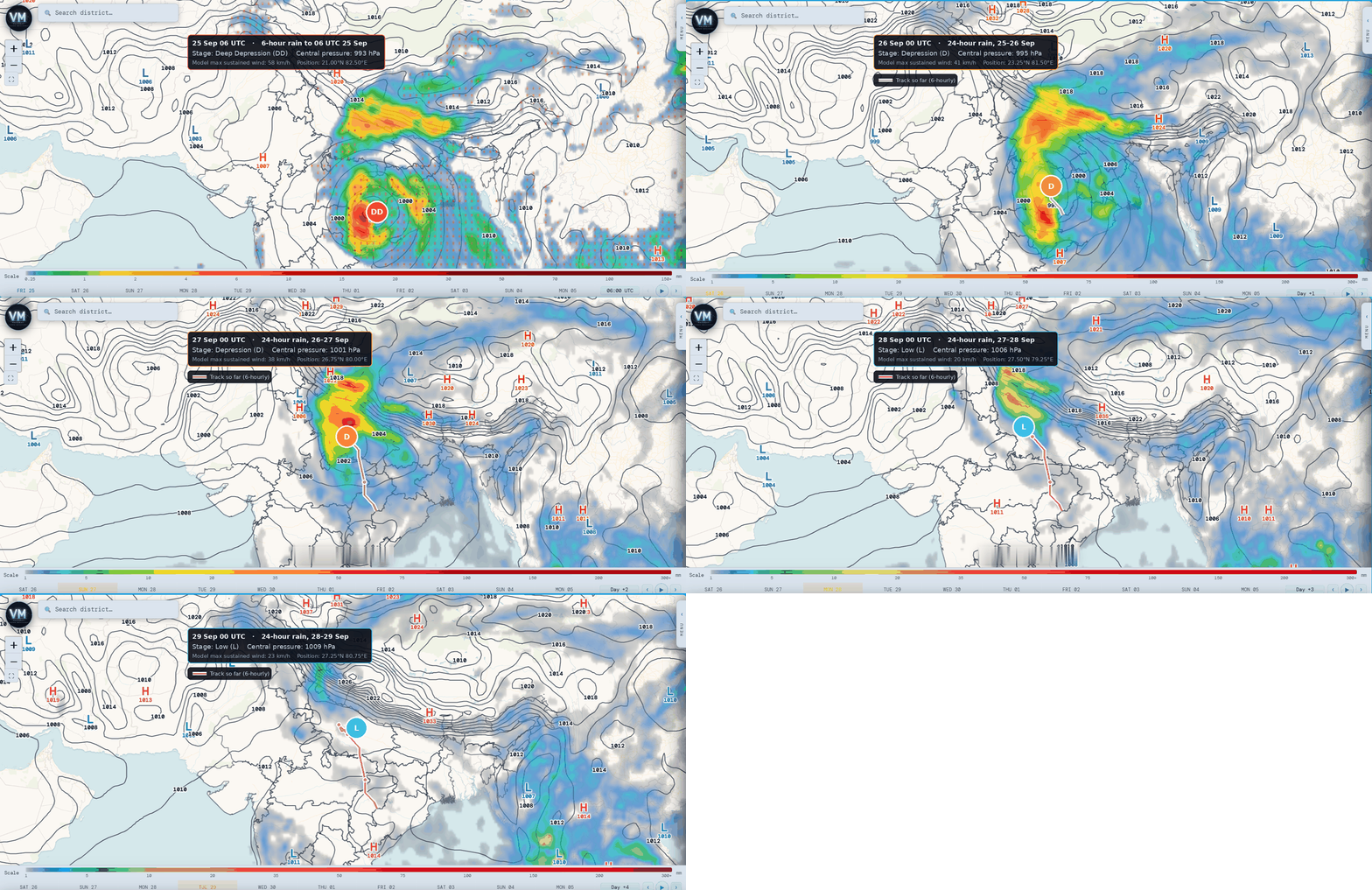
VayuMet rain + mean sea level pressure, 25–29 Sep 2026 · first frame 6-hour rain, remaining frames 24-hour rain · stage marked DD / D / L from the 00 UTC 25 Sep run · magenta trail is the 6-hourly track so far
Three things are worth watching as it loops.
The centre fills, and the marker walks down the ladder. 993 hPa over Mahasamund on the 25th, 995 over Shahdol on the 26th, 1001 over Kanpur on the 27th, 1006 over Etah on the 28th, 1009 over Sitapur on the 29th. Deep Depression, Depression, Depression, then low, then low. By the last two frames the closed isobars around it have gone entirely — what the marker sits on is a weak trough, not a circulation.
The track bends north and then loses the plot. The trail runs cleanly north-northwest from Chhattisgarh through Madhya Pradesh to the Ganga plain, then stalls and wanders over central Uttar Pradesh in the last two frames, backing east again towards Sitapur. That aimlessness is the signature of a system that has stopped steering itself and is being pushed around by the flow it sits in.
The rain outruns the centre — this is the part that matters. Watch the red core in frames two and three. It is not on the marker; it has slid north and northeast of it, onto the Uttar Pradesh plain and up against the Himalayan foothills, where the moisture is forced to rise. The heaviest rain of this whole sequence falls on 25 and 26 September, after the system has already been downgraded twice.
The Two Days That Matter
The animation is a story about weakening. The warnings are not. They peak on 25 and 26 September, and they are concentrated well north of where the system actually is:
| Date | Where | Warning |
|---|---|---|
| 25 Sep | Bahraich, Lakhimpur Kheri, Sitapur, Shrawasti, Lucknow, Barabanki (Uttar Pradesh) · Balod, Durg, Dhamtari, Rajnandgaon, Bemetara (Chhattisgarh) | Very Heavy |
| 26 Sep | Sitapur, Hardoi, Shahjahanpur, Lakhimpur Kheri, Bareilly (Uttar Pradesh) · Pithoragarh (Uttarakhand) | Very Heavy |
| 27 Sep | Bijnor, Moradabad, Rampur, Pilibhit, Amroha (Uttar Pradesh) · Udham Singh Nagar, Uttarkashi, Garhwal, Haridwar (Uttarakhand) · Kinnaur (Himachal Pradesh) | Heavy |
| 28–29 Sep | No warning-level rain from this system; scattered thunderstorms only over the northwest plains | Clearing |
Model guidance only — verify against latest IMD district bulletins.
The wind story is separate, and it is worth reading carefully. Gusts in the 80–90 km/h band are flagged over Balrampur, Gonda, Shrawasti, Siddharthnagar, Bahraich and Basti on 25 September, and over the same belt again on the 26th. These are convective gusts — thunderstorm downdraughts inside the rain band — not the system's own circulation, which by then is barely managing 40 km/h near the centre. A dying system can still throw a damaging squall.
Watch — central and eastern Uttar Pradesh and the Uttarakhand foothills, 25–27 September: Very Heavy Rain is flagged across a belt from Bahraich and Shrawasti through Sitapur and Hardoi to Bareilly and Pithoragarh, with convective gusts of 80–90 km/h on the first two days. Saturated ground from the season's rain plus fast-draining foothill terrain makes river rise and local flooding the hazard here. Follow IMD's district bulletins for the operational warning.
Comments
⚠ Disclaimer
VayuMet's analysis is based on NOAA GFS model output and represents independent meteorological assessment. Before taking any decision based on weather forecasts, always consult your national official meteorological broadcaster for authoritative guidance.
Data Source: Frames captured from the VayuMet live map (rain + mean sea level pressure), NOAA GFS 00 UTC 25 Sep 2026 run · Centre positions and stage marks derived from that run's pressure and 10 m wind fields. Over land the near-centre wind maximum includes convective gusts and therefore runs high, so the stage marks are capped at Deep Depression and should be read as model guidance: IMD's classification is the authority · Rainfall warnings: VayuMet district warning system, IMD rainfall categories