Rise and Fall of a Giant: A Bay of Bengal Depression in Motion
It began as a shapeless low over the Andaman Sea a few days ago. This morning it is a Deep Depression sitting just off the north Andhra Pradesh coast near 18.0°N, 84.25°E, central pressure down to 984 hPa — the deepest this system has been, and its peak. Everything from here is descent: over the next five days it crosses the coast, grinds west-northwest through Telangana and Vidarbha, and quietly comes apart over Madhya Pradesh. The six frames below are the VayuMet rain-and-pressure map stepped through that decline, stitched into one loop.
The Whole Life Cycle in One Loop
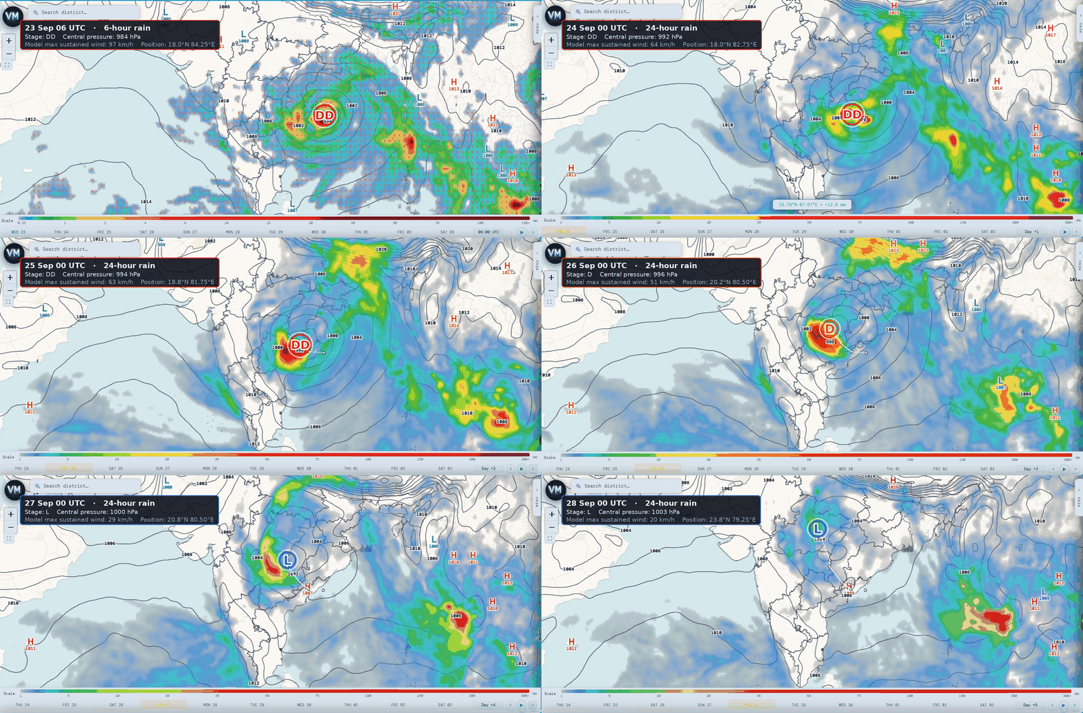
VayuMet rain + mean sea level pressure, 23–28 Sep 2026 · loop begins at peak intensity · first frame 6-hour rain, remaining frames 24-hour rain · stage marked DD / D / L, white trail shows the track so far
Three things are worth watching as it loops.
The centre marches west-northwest, then turns north. It starts hard against the coast at 84.25°E and ends at 79.25°E — roughly 550 km inland — but the last two frames show it also swinging sharply north, from 20.75°N to 23.75°N in 24 hours, as the steering flow lifts it away from the peninsula.
The pressure fills steadily and the stage marker follows it down. 984 hPa at the coast, 992 by 24 September, 996 by the 26th, 1003 by the 28th. The marker walks the ladder with it: Deep Depression, then Depression, then merely a low.
The rain shield outlives the circulation. Watch the red and orange rain core: it stays large and violent through frames two and three, long after the centre has lost the sea it fed on, and only thins out in the last two frames. By 28 September there is barely any colour left on the map — the system has become a pressure feature with no weather attached.
The Two Days That Matter
The animation is a story about weakening, but the danger is front-loaded. The warnings peak on 24 and 25 September, when the system is inland but still strong:
| Date | Where | Warning |
|---|---|---|
| 23 Sep | Alluri Sitharama Raju, Anakapalli (AP) · Malkangiri (Odisha) | Very Heavy |
| 24 Sep | Bhadradri Kothagudem, Mahabubabad, Mulugu (Telangana) · Sukma (Chhattisgarh) · Malkangiri (Odisha) | Extremely Heavy |
| 25 Sep | Adilabad, Kumuram Bheem Asifabad, Mancherial (Telangana) · Chandrapur (Maharashtra) | Extremely Heavy |
| 26 Sep | Adilabad, Kumuram Bheem Asifabad (Telangana) | Very Heavy |
| 27–28 Sep | Isolated Heavy Rain over Uttar Pradesh only | Clearing |
Model guidance only — verify against latest IMD district bulletins.
Winds follow the same curve. Gusts reach 75 km/h over Eluru and East Godavari on 24 September and peak at 84 km/h over Kumuram Bheem Asifabad and Adilabad on the 25th — inland, well after the coast crossing, which is typical of a system still drawing on its own circulation rather than the sea.
Watch — Telangana, east Vidarbha, south Chhattisgarh and south Odisha, 24–25 September: Extremely Heavy Rain (≥ 204.5 mm/24h) is flagged on both days across a belt running from Malkangiri and Sukma through Bhadradri Kothagudem and Mulugu to Adilabad and Chandrapur. This is hilly, fast-draining terrain — flash flooding and river rise are the hazard, not wind. Follow IMD's district bulletins for the operational warning.
Comments
⚠ Disclaimer
VayuMet's analysis is based on NOAA GFS model output and represents independent meteorological assessment. Before taking any decision based on weather forecasts, always consult your national official meteorological broadcaster for authoritative guidance.
Data Source: Frames captured from the VayuMet live map (rain + mean sea level pressure), NOAA GFS 00 UTC 23 Sep 2026 run · Stage marks and centre positions derived from that run's pressure and 10 m wind fields, and capped at Deep Depression: the model's own wind field is stronger than that on 23 September, but IMD has issued no classification above Deep Depression, and IMD's classification is the authority · Rainfall warnings: VayuMet district warning system, IMD rainfall categories