Arnab Rising: The Bay of Bengal Brews Its First Storm of 2026
🌀 The picture has gone clear. Three days ago a Bay system was a maybe; the 22 October run leaves little room for doubt — a tropical storm is forming over the central Bay of Bengal. A depression takes shape on 23 October, stalls for two days while it organises, then runs west-northwest and reaches Very Severe Cyclonic Storm strength before crossing the coast near Srikakulam on the north Andhra Pradesh coast late on 27 October. And when it passes Cyclonic Storm strength it inherits a name that has been waiting all season, because 2026 has not used one yet: Arnab.
🎞️ Six Frames: Depression to Very Severe, and Inland
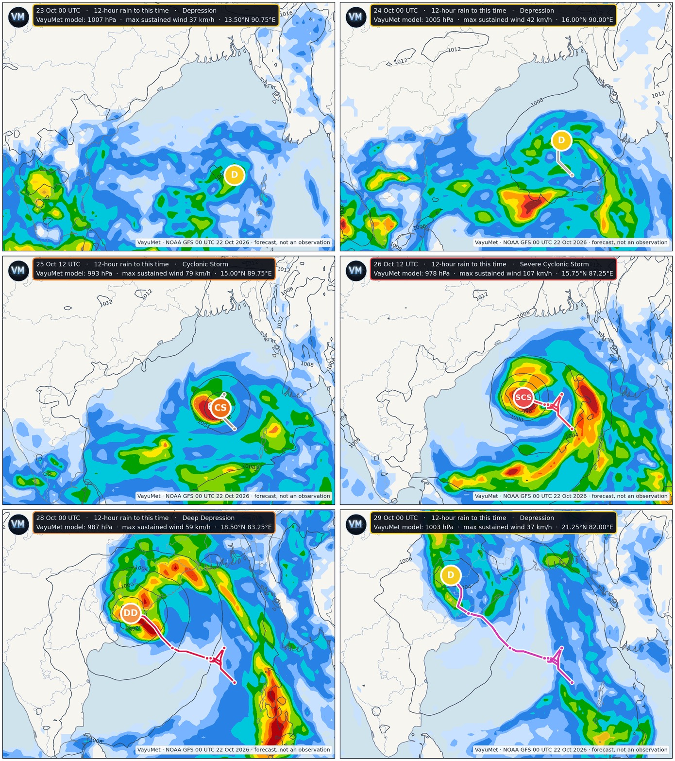
VayuMet model, NOAA GFS 00 UTC 22 Oct 2026 · 12-hourly frames, 23–29 October · 12-hour rain and mean sea level pressure · stage from this run's own pressure and 10 m wind fields · magenta trail is the 6-hourly track · forecast, not an observation
The sequence is unusually tidy for a model at this range. The system sits almost stationary over the central Bay for two days, drifting barely 100 km while it organises — and that stall is what buys it the time to deepen. Only on the 26th does it move west-northwest in earnest, and by then it is already a Severe Cyclonic Storm.
📊 The Track, Stage by Stage
| Valid (UTC) | Position | Central P | Max wind | Stage |
|---|---|---|---|---|
| 23 Oct | Central Bay, 13.5°N 90.8°E | 1007 hPa | 37 km/h | Depression |
| 24 Oct | 15.0°N 89.3°E | 1004 hPa | 65 km/h | Cyclonic Storm |
| 25 Oct | 15.0°N 89.8°E — stalling | 993 hPa | 79 km/h | Cyclonic Storm |
| 26 Oct | 15.5°N 88.0°E | 980 hPa | 104 km/h | Severe Cyclonic Storm |
| 27 Oct 12Z | 17.5°N 85.0°E — 130 km off Srikakulam | 964 hPa | 154 km/h | Very Severe Cyclonic Storm |
| 27 Oct 18Z | Coast crossing, Srikakulam | 969 hPa | 133 km/h | Very Severe Cyclonic Storm |
| 28 Oct | Inland, Vizianagaram → Koraput | 987 hPa | 59 km/h | Deep Depression |
Single deterministic run. Stage is this run's own wind speed on the standard cyclone scale.
⚠️ One number to keep in view: 300 km. Last week's run had the coast crossing at Kendrapara in north Odisha around 27 October near 953 hPa. This week's has it at Srikakulam, 300 km southwest, near 969 hPa. Same date, different coast. That is a normal amount of movement at six days, and it tells you what to trust: the timing has firmed up, the landfall point has not. Anywhere from north Andhra Pradesh to south Odisha is live, and the whole Odisha coast should stay on watch.
🏷️ If It Gets a Name, the Name Is Arnab
Here is the detail that makes this one notable beyond the track. The 2026 North Indian Ocean season has not produced a single cyclonic storm. Seven depressions, four of which reached Deep Depression, and not one of them crossed the threshold to be named. The season's strongest system so far peaked at 55 km/h.
Cross 62 km/h of sustained wind and that changes. The next unused name on the list is Arnab, contributed by Bangladesh, and it means "ocean" in Bengali — from the Sanskrit arṇava. A storm born in the middle of the Bay, named for the sea itself. The model has this system at 65 km/h by 24 October, which is the moment the naming question gets answered.
How the names are actually chosen
It is not a lottery, and not the forecaster's choice. Under the WMO/ESCAP Panel on Tropical Cyclones, thirteen member countries — Bangladesh, India, Iran, Maldives, Myanmar, Oman, Pakistan, Qatar, Saudi Arabia, Sri Lanka, Thailand, the UAE and Yemen — each submitted thirteen names, giving the 169-name list IMD released on 28 April 2020 as thirteen columns of thirteen.
- Strictly in order. Countries are listed alphabetically, beginning with Bangladesh, and names are used sequentially down the columns — irrespective of whether the storm forms in the Bay of Bengal or the Arabian Sea. When a column is exhausted the next begins.
- Only above 62 km/h. RSMC New Delhi — IMD — assigns the name when a system reaches Cyclonic Storm intensity. Depressions and deep depressions get numbers, not names.
- The naming rules are strict. A name must be neutral with respect to culture, politics, gender and religion, must not be rude or cruel, must be short and easy to pronounce, and must run to no more than eight letters. The Panel can and does reject submissions.
- Why bother at all. A name is faster to broadcast, harder to confuse when two systems are running, and far easier for a fisherman or a district officer to retain than a serial number. The first name India's region used was Onil, in 2004.
🌧️ The Severe Weather, If This Run Holds
| Date | Where | Rain | Model gusts |
|---|---|---|---|
| 26 Oct | Kendrapara, Jajapur, Bhadrak, Jagatsinghpur, Puri (Odisha) — outer bands | Heavy, isolated | 65–80 km/h |
| 27 Oct | Srikakulam, Vizianagaram, Parvathipuram Manyam (Andhra Pradesh) · Gajapati, Ganjam, Nayagarh, Khordha, Puri, Kandhamal (Odisha) | Very Heavy | 90–115 km/h |
| 28 Oct | Koraput, Nabarangapur, Malkangiri (Odisha) · Bastar, Kondagaon, Kanker, Balod (Chhattisgarh) | Heavy to Very Heavy | 55–65 km/h |
| 29 Oct | Remnant trough into Uttar Pradesh — Kanpur, Unnao, Hardoi, Lucknow | Heavy | 60–70 km/h |
Model guidance only — verify against latest IMD district bulletins.
Note how the hazard migrates. 🌊 Wind peaks on the coast on the 27th, Srikakulam the most exposed district in this run. 💧 Rain peaks hours later and further inland, over the Eastern Ghats of Gajapati, Kandhamal and Koraput — steep, fast-draining country where Very Heavy Rain becomes flash flooding and landslides, not slow flooding. And with the centre under 990 hPa at the coastline, storm surge is a live concern for low-lying Srikakulam and the Ganjam shore.
✅ What to Do With Five Days' Notice
Five days is enough to do everything that matters and still be wrong about the details. Nothing here is a warning — it is model guidance that has firmed up, and the preparation below costs little if the details move.
- 🎣 Fishermen. Be off the central and west-central Bay from 24 October. Boats on long trips should be running their return leg now, not planning the next.
- 🏛️ District administrations — Srikakulam, Vizianagaram, Gajapati, Ganjam and the Odisha coast. Shelters, ODRAF and NDRF pre-positioning, evacuation lists for low-lying coastal tracts. These decisions take days and the window is open now.
- ⚡ Power, telecom, transport. Crews and spares in place by 26 October. At 115 km/h gusts, distribution poles and the Howrah–Chennai corridor are both in play.
- 🌾 Agriculture. Standing paddy across coastal Andhra and south Odisha is the most exposed asset in the path. Harvest early where the crop allows, and clear field drainage.
- 🏠 Households in the likely path. Secure roofing and water tanks, keep 72 hours of water, medicines and charged power banks, know your nearest shelter. If the wind drops suddenly at landfall, that is the eye — stay inside.
- 📻 Everyone. Follow IMD bulletins and your State Disaster Management Authority. Model guidance sets your posture; only the official warning sets your actions.
What would change this. The landfall point has already moved 300 km between two runs — expect it to move again. Watch the 23 and 24 October runs: once the depression actually exists and is being tracked rather than predicted, the spread narrows fast. If it tracks a little further north the Odisha coast takes the core; a little further south and it is north Andhra's storm entirely. And if intensification stalls below 62 km/h there is no name at all, and 2026's strange run of unnamed depressions simply continues.
Comments
⚠ Disclaimer
VayuMet's analysis is based on NOAA GFS model output and represents independent meteorological assessment. Before taking any decision based on weather forecasts, always consult your national official meteorological broadcaster for authoritative guidance.
Data Source: NOAA GFS 00 UTC 22 Oct 2026 · Centre positions, central pressure and stage derived from that run's own mean sea level pressure and 10 m wind fields · The system has not formed yet. Stages named here are this run's own wind speeds placed on the standard cyclone scale, and the name "Arnab" applies only once a system is formally classified at Cyclonic Storm intensity · Rain and gust warnings: VayuMet district warning system, IMD rainfall categories · Naming list, rules and season status: WMO/ESCAP Panel on Tropical Cyclones and IMD's 2020 list of 169 names, with 2026 season counts from published season records.